
664 Woodville Hwy, Crawfordville, FL 32327 850-421-3248 between Tallahassee and St. Marks, FL.
by Capt. Tony Murray
When planning a trip to perform reconnaissance of an area as presented in last weeks fishing report, there are a variety of considerations necessary to make the most out of your venture while not knocking your prop and while above all else staying safe.
First, some of the more obvious considerations for our area:
1) Be aware that the reported tides are relative to the wind speed and direction. Typically in winter when the North wind has blown for an extended amount of time, this blows a substantial amount of water out of the bay. Consequently, the water is substantially lower than the referenced tide.
2) Use a reference rock or piling in the area to gauge your site-specific water level.
3) Not only know what the tides are, but take a copy of the tide chart with you. Depending on your GPS, you most likely have a tide chart available on your GPS, use this as a reference and separately confirm.
4) Watch your bottom profiler and correlate the color, turbulence and flow of the water with various subsurface conditions.
5.) Know the draft of your vessel and your motor and be familiar with how your vessel handles under low idle speeds with the motor trimmed up. Steerage is severely hampered in these conditions. Have a spotter on the front that is keeping a sharp eye directly in front and on both sides of the bow.
6) Read the waters ahead of you and behind you; remember you are in a dynamic situation and when the tide drops you may not be able to clear areas that you previously did; or conversely when the tide rises you will not be able to identify the oyster bars and rocks that you did on your way in.
7) Try and recon when the water is the clearest, dont go after a series of large storms when the water is turbid and a fresh flush of dark water (tannins) have been flushed into the system; in fact going on a cold, clear, windless day will give the best visibility into the water.
8) It is important to have obtained and reviewed the charts for the specific area that you are reconning. It is most important to understand the symbols and information presented. I also review a variety of websites and obtain aerial photos of the areas.
9) Keep an eye on your compass as well as your GPS; and of course the weather.
10) Do you have a contingency plan if you wrap your prop?
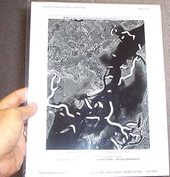
Now for some of the less obvious considerations: 1) Make a copy of the area of interest at the appropriate resolution (and tide), the picture to the right is double sided and plasticated. Plan ahead of time your entrance and exit strategy in the area. This aerial photo was obtained from Terraserver; image courtesy of the U.S. Geological Survey. A grease pencil works well on this plasticated map for notes and info.
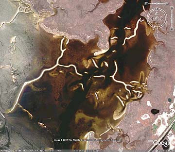
2) Although both Terraserver and Google Earth present Lat/Longs, ground truth numbers, make sure they are in the same coordinate system and are properly georectified. Here is where you will get the best resolution to review holes, channels, and flow inputs from streams and areas to investigate. 3) Check separate references of the same areas, because some of the sand bars migrate via seasons and after storm events, such as at the West Pass of St. George. The picture below is from Google Earth courtesy of Florida Department of Environmental Protection at a similar resolution.
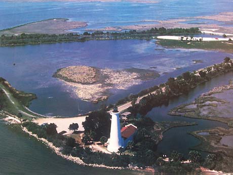
4) Right next to the Google Earth picture, is a picture taken of a photo on my wall (St. Marks Refuge Association photo by Lee Cook). Note the bars are not visible in this photo although some slick areas on the surface of this water correspond with these oyster bars.
THE MAIN CONCEPT is to know the limits of your GPS to use it reliably (I carry two, by the way); when navigating these locations. Don't depend on your 'bread crumb' or 'rabbit trail' - as I call the dots left on the gps when in tracking mode; the accuracy on this can easily be off by 50' feet or more; which can cost you a prop, lower unit or worse...
I go safely to a known position and key that exact starting waypoint (Safe Waypoint 1); note your pdop (number of satellites/thus your accuracy level) then secure that exact waypoint with your comfort level of accuracy (i.e. 10'/3 meters).
Then take an exact bearing (and I mean exact) to where your next safe point (what will be your Safe Waypoint 2) will be - and I make it a convenient number if possible (i.e. 180 degrees - due South); note any windage and what you want to do is make an exact (and I mean exact) straight line to your next location. Here is where you trust and lock in on your electronic heading (i.e. 90 degrees;) and also keep a good eye on your compass (this is where you will note a site specific deviation in your magnetic compass versus your gps compass); I also carry a handheld site compass to check compass variation/deviation. Go slowly; look for hidden obstacles - not only directly in front of you but also on each side. If in doubt, have your push pole handy and tap it. Then when you get to your next location (Safe Waypoint 2); again create your second waypoint. The use of these convenient
degree headings (e.g. 90 and 180) is used in areas such as initial entrance into the Rock Garden and cannot be practically applied in the above oyster bar area.
Remember on this reconnaissance that it is not the obstacle that you can currently see (at low tide with a North wind blowing) right now that will get you, it is the one you can't clear. I go to the tip of the oyster bar, rock, or area of interest and then obtain the most precise and accurate gps coordinate that I can. Take good notes, and know how much clearance you will have in the future when the water levels are higher.
Then on your way back, move over 5 feet (if you have that much leeway, such as at the Rock Garden) and navigate back from Safe Waypoint 2 to Safe Waypoint 1 - on the inverse of your original heading; i.e. 0 degrees/due North). I also keep a handful of small weighted buoys handy to mark areas of interest, concern, or where I consistently take hits when on a drift.
If in doubt, go slowly and be safe and dont let an apparent sense of familiarity with these waters lessen the required level of keen and continual observation. Capt. Tony Murray
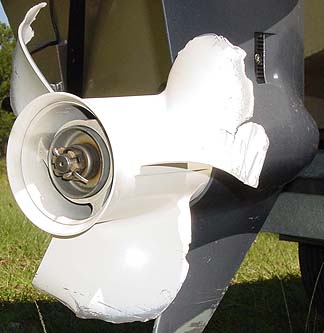
this "rock-treated prop" belongs to Mark, but unfortunately,
this is very common in our area. I took this picture in October and I thought it would be appropriate to include it with Tony's story. I really hate it when this happens. It can spoil all the fun. -Scott
Tony will host a class on March 15th. He will discuss navigation in our area, bay and rivers and methodologies used to carefully plan, map and avoid obstacles using your gps, compass, computer, charts, maps and observation. In addition, Tony will discuss aspects of weather which will include fish feeding activity levels based on weather/sun-moon patterns as well as methodologies to assess and monitor your specific areas expected weather patterns for more extensive trips To reserve call 850-421-3248 or email: TMSeatrout@earthlink.net.
Avoid busting your lower unit!
and don't forget that this website is supported by:


If you are interested in advertising here, please contact us at 850-421-3248 or email us


Any photograph or other digital image provided to Jerry's Bait & Tackle may be used at the sole discretion of the owners of said establishment and may also be utilized and/or published in other media without prior consent or permission. Neither Jerry's Bait & Tackle nor the owners of said establishment may be subject to any claims for their use of the above-referenced photographs or digital images. Provision of these images is equivalent to consent consistent with the above language.
